


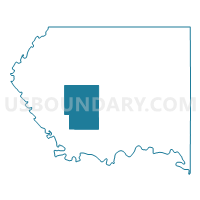
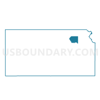
Pottawatomie County Voting District, Pottawatomie County, Kansas
About
Outline

Summary
| Unique Area Identifier | 586304 |
| Name | Pottawatomie County Voting District |
| County | Pottawatomie County |
| State | Kansas |
| Area (square miles) | 59.92 |
| Land Area (square miles) | 59.71 |
| Water Area (square miles) | 0.21 |
| % of Land Area | 99.65 |
| % of Water Area | 0.35 |
| Latitude of the Internal Point | 39.33511500 |
| Longtitude of the Internal Point | -96.45436670 |
Maps

Graphs
Select a template below for downloading or customizing gragh for Pottawatomie County Voting District, Pottawatomie County, Kansas


Neighbors
Neighoring Voting District (by Name) Neighboring Voting District on the Map
- Blue Township Voting District, Pottawatomie County, KS
- Green Township Voting District, Pottawatomie County, KS
- Louisville Township Voting District, Pottawatomie County, KS
- Rock Creek Township Voting District, Pottawatomie County, KS
- Shannon Township Voting District, Pottawatomie County, KS
- St. George Township Voting District, Pottawatomie County, KS
- Union Township Voting District, Pottawatomie County, KS
Top 10 Neighboring County Subdivision (by Population) Neighboring County Subdivision on the Map
- St. George township, Pottawatomie County, KS (3,415)
- Blue township, Pottawatomie County, KS (3,046)
- Louisville township, Pottawatomie County, KS (803)
- Rock Creek township, Pottawatomie County, KS (740)
- Pottawatomie township, Pottawatomie County, KS (601)
- Shannon township, Pottawatomie County, KS (270)
- Union township, Pottawatomie County, KS (224)
- Green township, Pottawatomie County, KS (184)